Easy Lookup, Impossible Vision
Why is this AI ML meme funny?
Level 1: Map Easy, Seeing Hard
Imagine someone asks, "Is this toy inside the toy box?" That is easy if you can look at a map of the room. Then they ask, "Is this blurry picture showing a real bird, a toy bird, or a bird drawing?" That is much harder because you have to understand what you are seeing. The meme is funny because both requests sound small, but one is a simple map question and the other is a hard seeing question.
Level 2: Coordinates Versus Vision
A GIS lookup uses geographic information. If an app knows a photo was taken at a latitude and longitude, it can compare that point with a map of national park boundaries. This is like asking, "Is this dot inside this shape?" It can still take work, but developers already know many standard ways to solve it.
Checking whether a photo contains a bird is different. The computer has to interpret an image. Older approaches used handcrafted image-processing rules, but those rules break easily when lighting, angles, backgrounds, or object sizes change. Modern systems usually use machine-learning models trained on many labeled images. That means the result is probabilistic: the model may be confident, uncertain, or confidently wrong.
The comic is funny because both requests sound like simple yes-or-no checks. One asks the computer to compare known data. The other asks it to understand the visual world. For a new developer, this is an important lesson: similar-looking requirements can hide completely different levels of difficulty.
Level 3: Easy Until Pixels
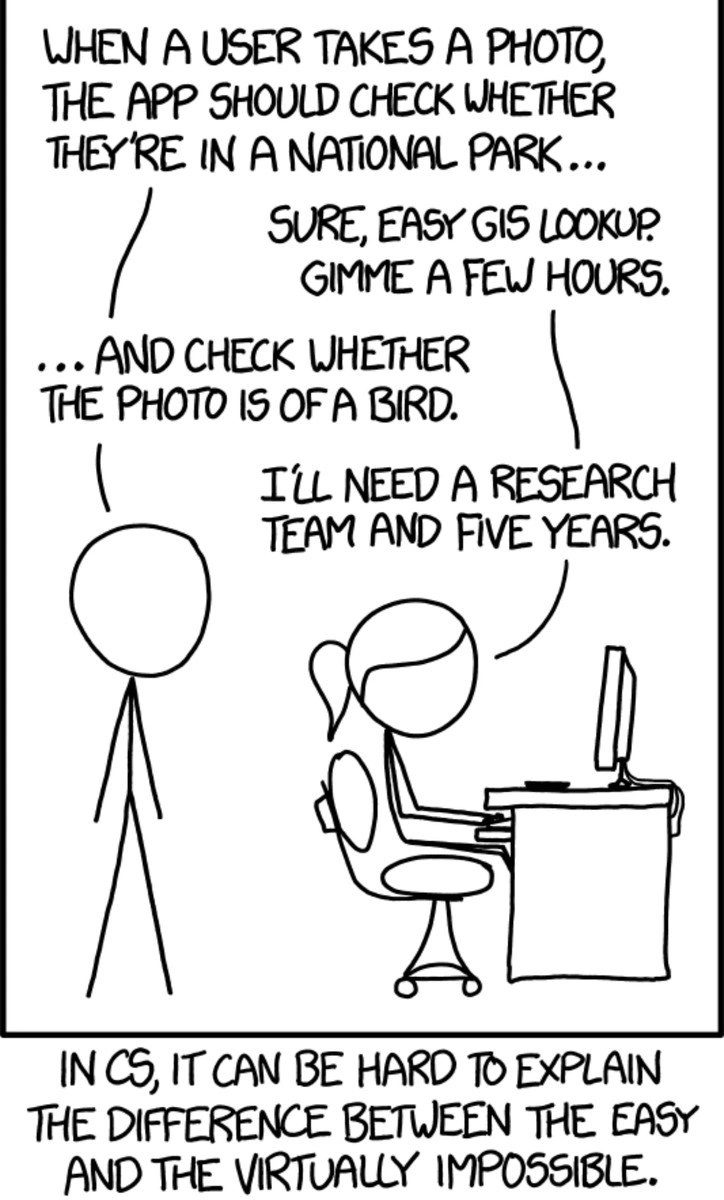
The comic's entire punchline is the mismatch between how simple two requirements sound and how different they are as computer science problems. The requester starts with:
WHEN A USER TAKES A PHOTO, THE APP SHOULD CHECK WHETHER THEY'RE IN A NATIONAL PARK...
The developer answers:
SURE, EASY GIS LOOKUP. GIMME A FEW HOURS.
That part is relatively bounded. If the phone gives you GPS coordinates, and you have a dataset of national park boundaries, checking whether a point lies inside a polygon is ordinary GIS work. There are annoying details, because there are always annoying details: missing EXIF data, stale boundary files, coordinate systems, privacy permissions, edge cases near borders, offline behavior. But the shape of the solution is known. It is a lookup problem with well-defined inputs and outputs.
Then the requester adds:
... AND CHECK WHETHER THE PHOTO IS OF A BIRD.
The developer replies:
I'LL NEED A RESEARCH TEAM AND FIVE YEARS.
That escalates from structured data to perception. A bird in a photo can be tiny, blurry, hidden behind leaves, reflected in water, painted on a sign, printed on a shirt, partially cropped, or confused with a drone, kite, statue, or very ambitious leaf. The input is not a coordinate pair anymore; it is a messy grid of pixels that requires MachineLearning, ImageProcessingAlgorithms, training data, model evaluation, false-positive trade-offs, and a definition of what "of a bird" even means.
The bottom caption says:
IN CS, IT CAN BE HARD TO EXPLAIN THE DIFFERENCE BETWEEN THE EASY AND THE VIRTUALLY IMPOSSIBLE.
That is the senior-engineer pain point. Stakeholders often estimate by sentence length. "Check whether they are in a national park" and "check whether the photo is of a bird" are both short phrases, so they feel similar. But one maps to a mature spatial query, while the other used to imply open-ended computer vision research. Modern AI vision models have changed the practical landscape, which matches the post message's sense that we are in a different world now, but they have not erased the product questions: how accurate is accurate enough, what happens when the model is wrong, who reviews borderline cases, and what does the system promise to users?
The meme is a clean example of SoftwareEstimation failure caused by RequirementsAmbiguity. The hard part is not typing isBird(photo). The hard part is making that function behave acceptably across the real world, where the real world has terrible lighting and no respect for sprint commitments.
Description
A black-and-white stick-figure comic shows one person requesting, "When a user takes a photo, the app should check whether they're in a national park..." and a developer at a desk replying, "Sure, easy GIS lookup. Gimme a few hours." The requester then adds, "... and check whether the photo is of a bird," and the developer answers, "I'll need a research team and five years." The caption at the bottom says, "In CS, it can be hard to explain the difference between the easy and the virtually impossible." The joke contrasts simple geospatial metadata or coordinate lookup with historically hard computer vision and image classification problems that sound equally simple to non-specialists.
Comments
8Comment deleted
The product spec said `isBird(): boolean`; the implementation notes said `invent modern computer vision`.
Well... they gave her a research team and five years. Comment deleted
It is hard when work is underpaid. Even harder if they pay too much Comment deleted
The app will also check all user's local photos in case there's any CP Comment deleted
And will recommend new based on user's preferences? Comment deleted
And perform AI photo enhancement Comment deleted
— ... and check whether the photo is of a bird. — sure, gimme python and chatgpt (🤢) Comment deleted
Plot twist: it's a photo of a cock Comment deleted